.png)

Urgent Red Flag Warning in Colorado: Extreme Fire Danger, 60 mph Winds and 6% Humidity Creates a Particularly Dangerous Situation
.jpg)
Description: The National Weather Service issues an urgent Red Flag Warning for southern Colorado, including Colorado Springs and Pueblo, with dangerous winds up to 60 mph and humidity as low as 6%. Extreme fire risk today and Thursday could lead to rapid, uncontrollable wildfires and limited evacuation time.
URGENT - FIRE WEATHER MESSAGE National Weather Service Pueblo CO 1220 AM MDT Wed Apr 22 2026
Teller County/Rampart Range Including Pikes Peak and Florissant Fossil Beds National Monument- Fremont County Including Canon City/Howard/Texas Creek- San Luis Valley Including Alamosa/Del Norte/Fort Garland/Saguache- Southern Front Range Including Sangre De Cristo Mountains/Wet Mountains/La Veta Pass- Northern El Paso County Including Monument and Black Forest- Southern El Paso County Including Fort Carson and Colorado Springs-Pueblo County Including Pueblo- Huerfano County Including Walsenburg- Western Las Animas County Including Trinidad and Thatcher- Crowley County Including Ordway- Otero County Including La Junta and Western Comanche Grasslands- Eastern Las Animas County Including Pinon Canyon- Kiowa County Including Eads-Bent County Including Las Animas- Prowers County Including Lamar- Baca County Including Springfield and Eastern Comanche Grasslands- 1220 AM MDT Wed Apr 22 2026
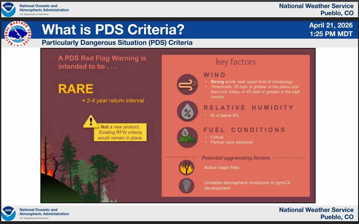
...THIS IS A PARTICULARLY DANGEROUS SITUATION TODAY FOR ZONES 224 AND 225...
...RED FLAG WARNING REMAINS IN EFFECT FROM 10 AM THIS MORNING TO MIDNIGHT MDT TONIGHT
The National Weather Service in Pueblo has issued a Red Flag Warning for gusty winds and low relative humidity, which is in effect from 11 AM to 9 PM MDT Thursday. The Fire Weather Watch is no longer in effect.
* THIS IS A PARTICULARLY DANGEROUS SITUATION TODAY FOR ZONES 224 AND 225
* AFFECTED AREA...Fire Weather Zones 221, 222, 224, 225, 226, 227, 228, 229, 230, 231, 232, 233, 234, 235, 236 and 237.
* TIMING...For the first Red Flag Warning, from 10 AM this morning to midnight MDT tonight. For the second Red Flag Warning, from 11 AM to 9 PM MDT Thursday.
* WINDS...For Zone 224 today, west-southwest 30 to 40 mph with gusts to 60 mph. For Zone 225 today, west-southwest 30 to 40 mph with gusts to 55 mph. For all remaining zones today, west- southwest 20 to 30 mph with gusts up to 40 mph. For all zones on Thursday, west 20 to 30 mph with gusts up to 40 mph, becoming northwest in the afternoon.
* RELATIVE HUMIDITY...As low as 6 percent.
* IMPACTS...Extreme fire danger is expected. Fires will uncontrollably spread and be very destructive.
PRECAUTIONARY/PREPAREDNESS ACTIONS...
This is a Particularly Dangerous Situation that poses a significant threat to life and property for both rural and urban environments in the event of a wildfire start or existing fire. In some cases, safe and timely evacuation may not be possible should a fire approach.
A Red Flag Warning means that critical fire weather conditions are either occurring now, or will shortly. A combination of strong winds, low relative humidity, and warm temperatures can contribute to extreme fire behavior.

Image Gallery
.jpg)