.png)

CDOT Warns Colorado Motorists to Prepare for Heavy Spring Snow and Hazardous Roads

Description: Colorado motorists should prepare for heavy, wet snow, slushy roads and hazardous travel statewide, including the Denver metro area and mountain corridors. Read the full Press release from Colorado Department of Transportation...
Motorists: prepare for a spring storm this week
Several inches of heavy, wet snow expected statewide, including the Denver metro area
Statewide - After weeks of summer-like weather, motorists must be prepared for rapidly changing conditions in the mountains, along the Front Range and in the Denver metro area as heavy spring snow is expected to cause wet, slushy and hazardous driving conditions early this week.
A potent late-season storm is set to affect Colorado beginning tonight, with peak impacts this Tuesday and Wednesday, May 5 and 6, bringing heavy snow to the mountains and beneficial moisture to the plains. While daytime temperatures on Tuesday will initially keep most pavement wet in the Denver metro area, heavy banded snowfall is expected to create difficult travel conditions in the high foothills and mountain corridors, including I-70 Mountain Corridor, Larimer and Boulder counties, with slushy accumulations expanding south across the Palmer Divide by Tuesday night. Travelers should prepare for the storm's peak impacts during the Wednesday morning commute, when cooling temperatures will likely lead to snow-covered roads at lower elevations before conditions begin to improve Wednesday afternoon.
Snow is expected to be wet and heavy with the possibility of breaking branches and downed powerlines. Wednesday morning rush hour is expected to be difficult across the Front Range with snow and icy conditions possible.
Denver Region
Snow shift starts prior to the storm on Tuesday. There will be about 100 plows throughout the storm with the focus on clearing interstates and major roadways first before the secondary roads. The anticipated challenge of this storm will be heavy wet snow possibly snapping tree limbs and falling into roadways.
Northern Colorado
Foothill areas of Boulder and Larimer counties will see most of the snow, but Tuesday night and into Wednesday morning could be dicey to just east of I-25 and eastern areas along I-70 could see accumulations as well.
I-70 Mountain Corridor
Some light impacts will develop tonight across the eastern mountains, including I-70, as the first piece of the storm moves through. Slushy to snow-covered impacts will expand across the mountains and foothills later Tuesday afternoon and especially evening once temperatures cool. Travel conditions could prove quite difficult and create visibility concerns as heavy bands of snow pass through the mountains during this period.
Southeast Colorado
Motorists on the I-25 corridor near the Palmer Divide can expect wet, slushy snow Tuesday night into Wednesday morning. Areas above 5,500 feet should be prepared for some snow accumulation west of Colorado Springs on US 24, through the Wet Mountains and the Sangre de Cristo Range.
Southwest Colorado
Winter driving conditions could make travel difficult on mountain passes including US 50 Monarch Pass between Salida and Gunnison and US 160 La Veta Pass between Alamosa and Walsenburg. Although significant snow accumulation is not anticipated in the southern San Juan Mountains, driving could be difficult at times and motorists should prepare for winter travel through Wednesday morning.
What motorists need to know:
- Prepare for slushy, hazardous driving conditions Tuesday through Wednesday, particularly in the high country.
- Give yourself extra commute time Wednesday morning along the Front Range.
- Avoid driving during the storm.
- Commercial motor vehicles are legally required to carry chains when traveling in Colorado's mountains.
- Chain and traction laws for trucks and passenger vehicles are likely.
- In the event of power outages, treat dark intersections as 4-way stops.
- Drive with care, including giving ample space behind the vehicle ahead of you and slow down.
- Please give plows and snow removal equipment room to safely clear the roadway.
- Be prepared with a snow kit (extra water, blankets, batteries, clothing, etc.) in your vehicle should there be road closures in the mountains.
- Check out cotrip.org for the latest road conditions.
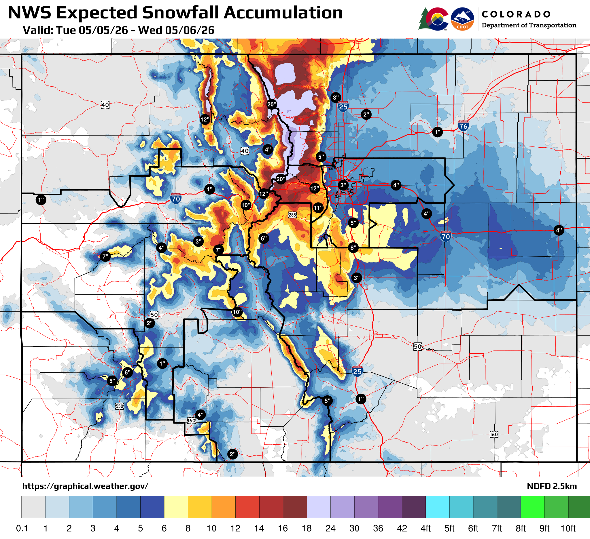
Graphic showing expected snowfall accumulations across Colorado.
Know Before You Go
Travelers are urged to “know before you go.” Gather information about weather forecasts and anticipated travel impacts and current road conditions prior to hitting the road. CDOT resources include:
- Road conditions and travel information: COtrip.org
- Download the COtrip Planner app: bit.ly/COtripapp
- Sign up for project or travel alerts: bit.ly/COnewsalerts
- See scheduled construction lane closures: bit.ly/laneclosures
- Connect with @ColoradoDOT on social media: Twitter, Facebook, Instagram and YouTube.