.png)

Aspen Acres Fire Reaches 100,224 Acres and 61% Containment After Drone Disrupts Air Operations
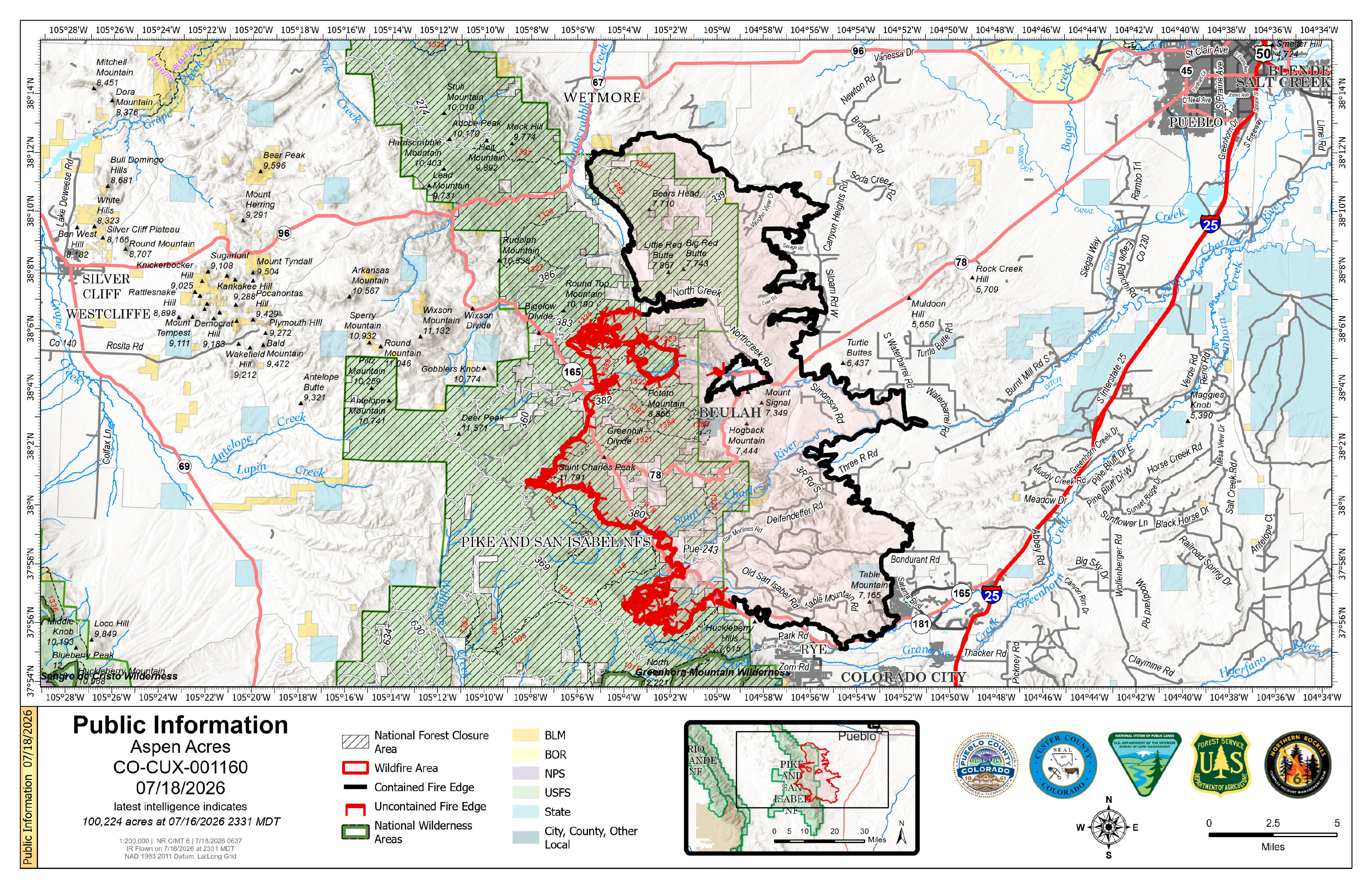
Description: The Aspen Acres Fire reached 100,224 acres and 61% containment as crews strengthened lines near Rye after an unauthorized drone temporarily halted aircraft...
Daily Update for Aspen Acres Fire 7/18/2026
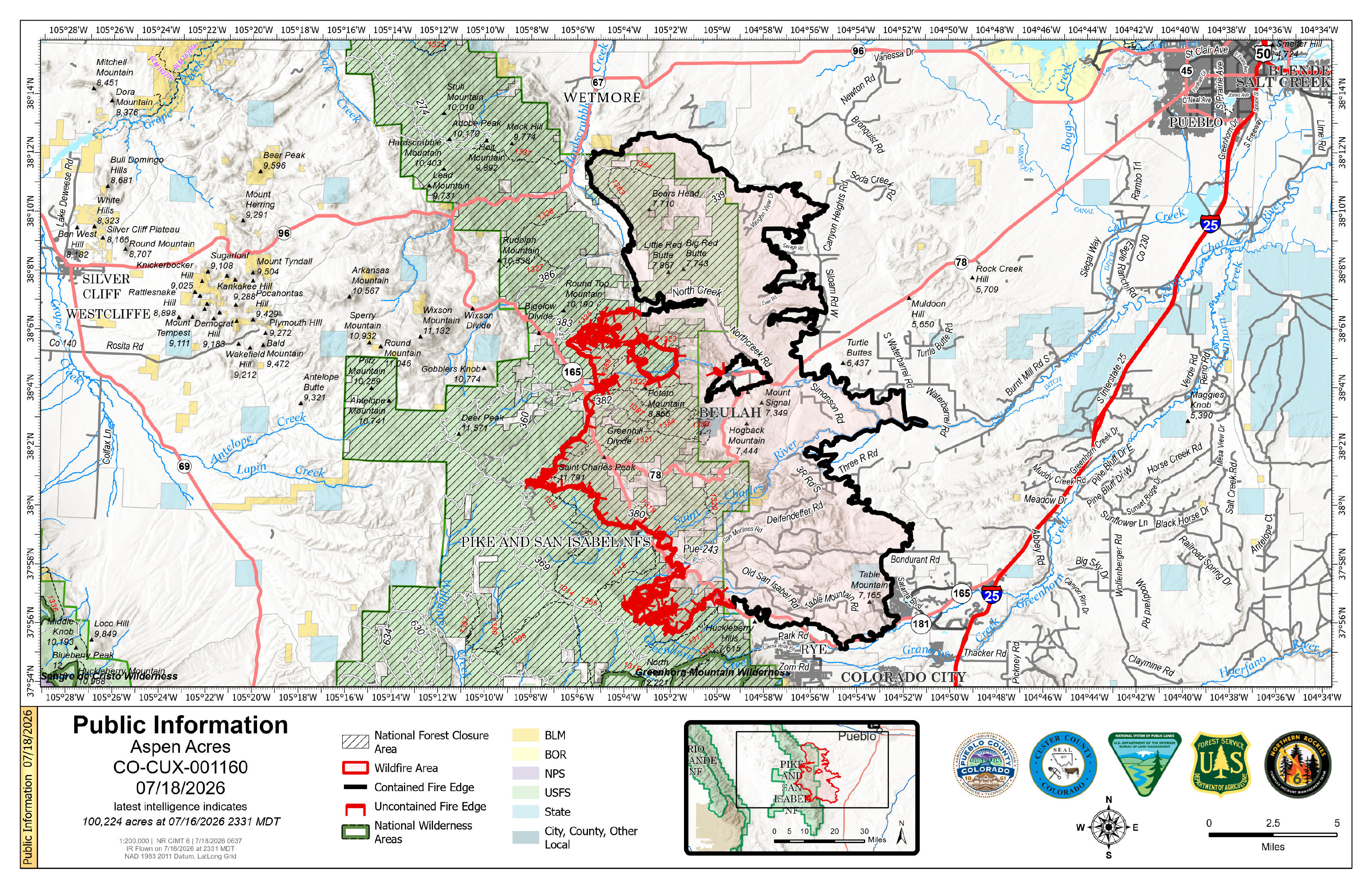
Location: 10 Miles NW of Rye, CO in Custer and Pueblo Counties
Start Date: Reported 06/29/2026 around 6:00 a.m.
Cause: Human, Under Investigation Official Acreage: 100,224 acres
Containment: 61% Total Personnel: 1,611
KEY MESSAGE
On Friday, an unauthorized drone (UAS) entered the fire airspace, forcing aircraft to temporarily stand down. Any unknown aircraft within the restricted airspace halts aerial operations and puts firefighters at risk. It's important for the public to understand that flying a drone near a wildfire is not only dangerous, it is a federal offense. If you fly, we can't. For reports from the public regarding UAS, please contact the Pueblo County Non Emergency Line at 719-583-6250.
Firefighters made solid progress yesterday across multiple parts of the incident. Overnight, fire activity stayed relatively quiet, allowing firefighters to strengthen previous gains. On the east edge, good progress has moved portions of the line into patrol, mop‑up, and initial repair work.
In the area referred to as the "chicken foot," some short‑range spotting occurred near Rye yesterday but was quickly caught by firefighters. Crews were also able to secure spotting north of the Greenhorn Mountain using both ground resources and aircraft. Firefighters worked through the night to reinforce those improvements, setting a solid foundation for today's operations.
To build on overnight progress, on Saturday, newly arrived hotshot crews will deploy to this area with support from aircraft to tighten lines and reduce the chance of fire spread. These highly trained teams specialize in working in the steepest, most difficult terrain and will focus their attention on the active fire front northwest of Rye. Strengthening containment here is critical due to the challenging landscape and proximity to nearby communities.
On the western side near Saint Charles Peak, San Isabel Lake, and northwest of Rye, crews continued improving primary and secondary defensive lines. Fire behavior in this area was less active than earlier in the week, giving firefighters a chance to strengthen the line and prepare for potential firing operations if conditions allow. Heavy machinery is working north of Round Top Mountain and the Mingus Ranch area to reduce future erosion concerns.
Burned Area Emergency Response (BAER) teams are also assessing burned areas to understand impacts to property, infrastructure, and watersheds. Their evaluations help determine where treatments are needed to reduce risks of flooding, mudslides, and erosion. Suppression repair continues in areas with established containment to protect nearby communities and natural resources.
A growing number of people have been entering the fire area. For everyone's safety, the public is asked to stay out of active fire zones so firefighters can work without interruption or added risk.
WEATHER AND FIRE BEHAVIOR
Today is forecasted to bring a warmer and drier pattern across the fire area, with mostly sunny skies and a low chance of rain. Easterly winds are expected to increase in the early afternoon, producing gusts around 20–25 mph. Most thunderstorms are expected to remain west and southwest of the fire, leaving only a minimal chance of lightning.
Weather conditions are expected to support more active fire behavior today, especially in areas with very dry fuels and steep terrain. On the southwestern side, conditions support surface fire spread with occasional torching and short‑range spotting. Fire activity could resemble what was observed yesterday. This mix of dry fuels, warm weather, terrain, and shifting winds means the fire still has growth potential.
AREA CLOSURE
There is an Aspen Acres Fire Area Closure for the San Carlos Ranger District. Visit: https://www.fs.usda.gov/r02/psicc/alerts/aspen-acres-fire-area-closure . Please monitor land managing agencies for other fire restrictions. The National Forest Lands are closed and are also in evacuation status.
There is a Temporary Flight Restriction (TFR) in place above the fire area. Flying any aircraft within the TFR is prohibited. This includes the use of drones, or unmanned aerial systems.
EVACUATIONS
An awareness status is in place for Fremont County, encouraging residents to stay informed, monitor official updates, and remain prepared.
In Pueblo County, evacuation status has been lifted for the north and northeastern portions of the Aspen Acres Fire perimeter. Residents south of Highway 96 and north of Highway 78 are allowed to return to their homes. All residents will remain in pre-evacuation status and must be prepared to leave should conditions change. Evacuation status remains on the south side of the fire, with Colorado City remaining in pre-evacuation status.
Area C-9B is adjusting back to pre-evacuation status on Saturday at 9am. Wetmore and Greenwood areas remain in pre-evacuation status. The area from Mackenzi Junction Highway 165 south to South Hardscrabble Road opened for residents with Rapid Tag re-entry cards on Friday. Other areas of Custer County affected by the fire remain in pre-evacuation and evacuation status. For Custer County re-entry questions or specific evacuation status, call 719-467-0271.
Huerfano County Sheriff's Office returned all Forest Service land North of CO-69 to the northern-most Huerfano County line to Pre-Evacuation Notice. This includes CR 630 North of CR 630.1 and CR 634 North of 634.2, as well as the entirety of the Greenhorn Wilderness Area. For further information, call 719-738-1044 to reach Huerfano County dispatch.
AIR QUALITY
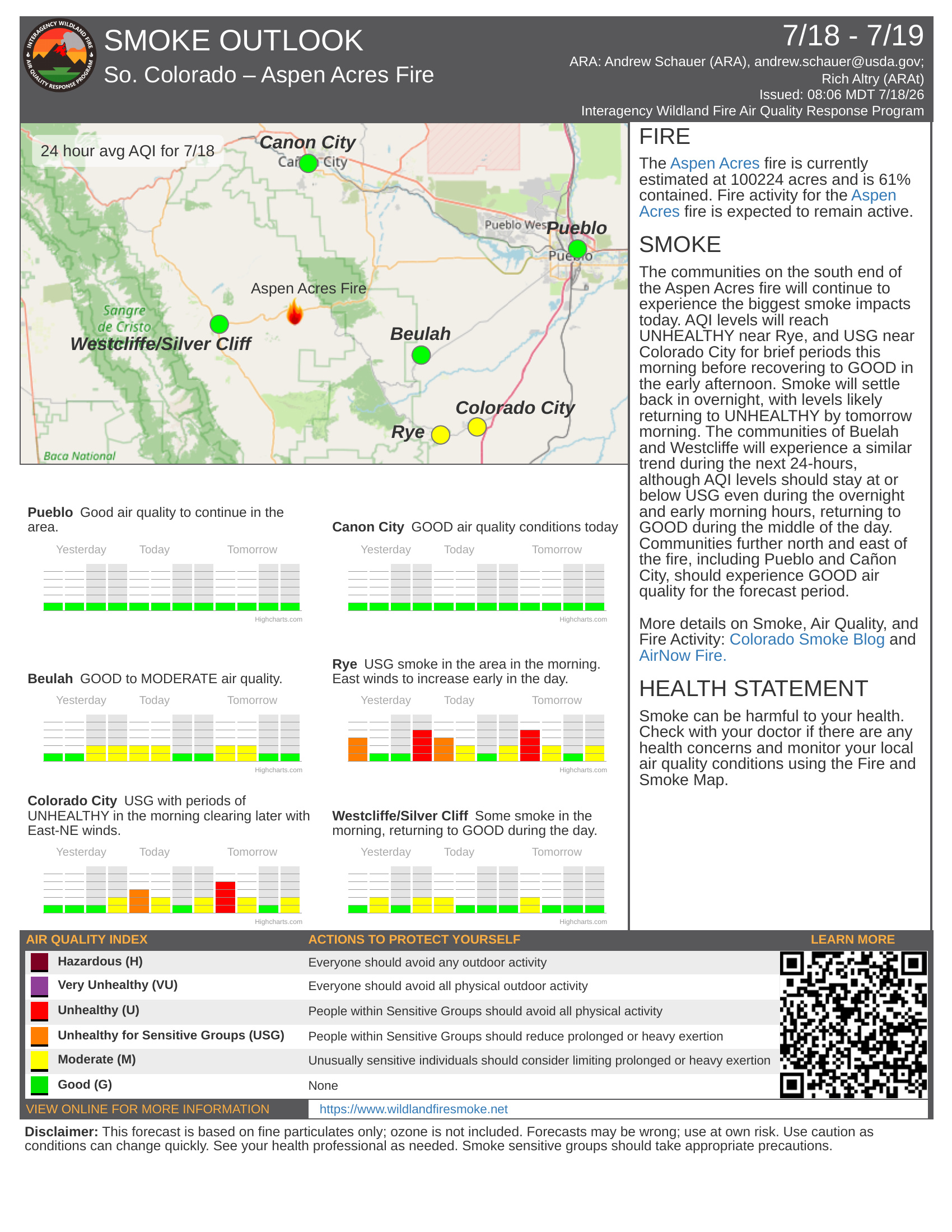
An Air Resource Advisor is assigned to the incident and assessing where communities may be impacted by smoke. To get daily air quality information, visit https://fire.airnow.gov/
OFFICIAL WEBSITES
The public and members of the media should monitor the following official websites:
Follow Pueblo County Sheriff's Office Facebook at www.facebook.com/PuebloSheriff and X: @PuebloCountySO https://x.com/PuebloCountySO.
Follow Custer County Sheriff's Office Facebook at https://www.facebook.com/CCSOAdmin.

Image Gallery