.png)

Aspen Acres Fire Holds at 61% Containment as Custer County Reopens Zones C3 and C4
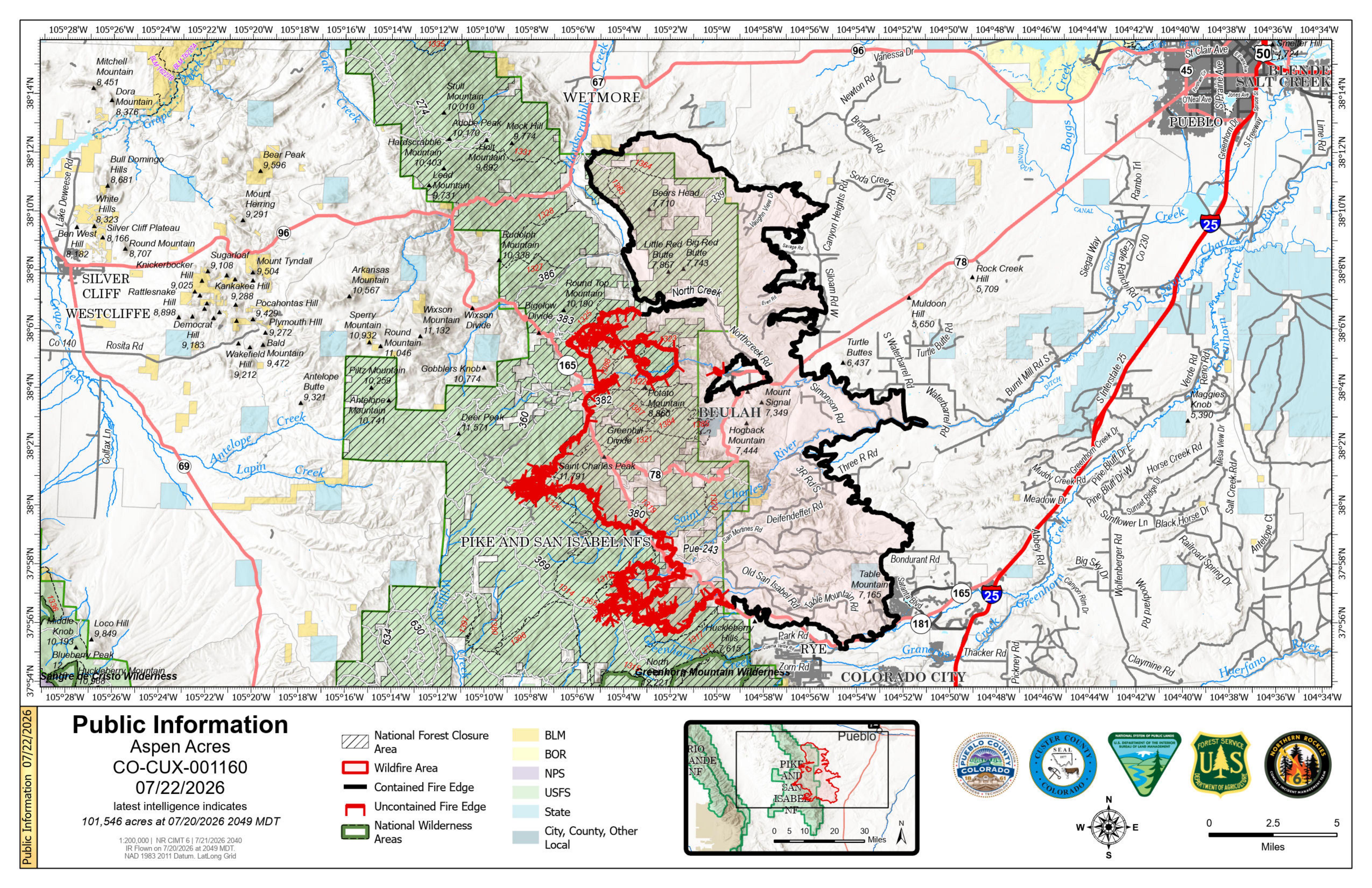
Description: The Aspen Acres Fire remains at 101,546 acres and 61% contained as crews strengthen lines near Rye and San Isabel, while Custer County reopens evacuation zones C3 and C4...
Daily Update Aspen Acres Fire for 7/22
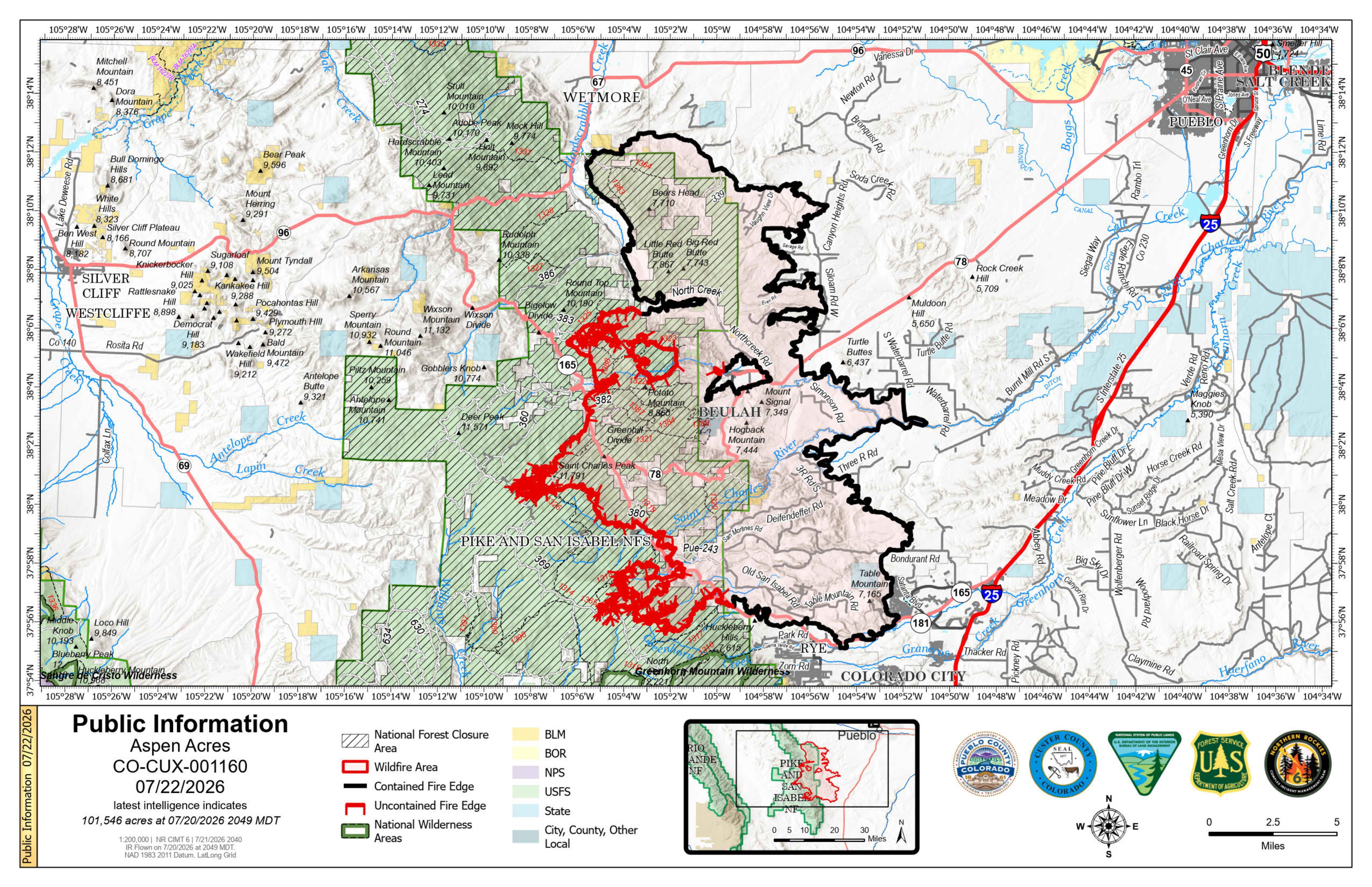
Location: 10 Miles NW of Rye, CO in Custer and Pueblo Counties
Start Date: Reported 06/29/2026 around 6:00 a.m.
Cause: Human, Under Investigation Official Acreage: 101,546 acres
Containment: 61% Total Personnel: 1,225
KEY MESSAGE
On Tuesday, fire fighters continued to secure control lines along the southwest flank of the fire to strengthen protections for the community of Rye. The fire remained within indirect containment lines despite the 100-acre slope over that crossed the primary containment lines on Monday.
If weather conditions allow, fire fighters may resume firing operations to strengthen primary containment lines near Rye, the San Isabel Community, and Saint Charles Peak. If firing operations occur, the residents and visitors can expect to see increased smoke.
Heavy machinery and air resources continued supporting crews working along the western perimeter of the fire to slow any additional growth. Fire activity increased near the San Isabel Community yesterday but stayed within defensive lines. A spike camp, a remote camp stocked with food and supplies, will be established near the San Isabel Community to support fire fighters staying closer to the fire perimeter. Near Saint Charles Peak, crews strengthened primary lines.
On the eastern side of the fire, fire fighters patrolled and responded to smoke reports near homes in repopulated areas, while continuing suppression repair and mop up.
Rain is possible across the burned areas today through the end of the week. Burned areas remain at increased risk for flash flooding and debris flows even with moderate rainfall. Residents should stay alert to emergency notifications, monitor weather activity, and if in a burned area move to high ground if a storm develops. For public and firefighter safety, please stay out of active fire areas so fire fighters and heavy equipment operators can work without added risk.
WEATHER AND FIRE BEHAVIOR
Tuesday brought temperatures in the lower 90s with afternoon showers and isolated storms with gusts up to 30 mph. Today, increased humidity is expected across the fire perimeter with increase chance of rain. Temperatures will range from the upper 80s to the lower 90s.
With the increased chance of rain and moisture, reduced fire behavior activity is expected. Any storms that develop over the fire area may produce lightning as well as erratic winds. Fire behavior could be influenced by terrain-driven winds, where the slope and wind align.
A flash flood warning will be in effect Thurs afternoon-Thurs evening. Refer to the National Weather Service for more information.
AREA CLOSURE
There is an Aspen Acres Fire Area Closure for the San Carlos Ranger District. Visit: https://www.fs.usda.gov/r02/psicc/alerts/aspen-acres-fire-area-closure. Please monitor land managing agencies for other fire restrictions. The National Forest Lands are closed and are also in evacuation status.
There is a Temporary Flight Restriction (TFR) in place above the fire area. Flying any aircraft within the TFR is prohibited. This includes the use of drones, or unmanned aerial systems.
EVACUATIONS
Evacuation Zones C3 and C4 in Custer County will reopen on Wednesday, July 22 at 10a.m. A re-entry tag listing your zone is required at traffic control points. Re-entry tags are available at the Disaster Assistance Center (DAC) at Lange Hall, 310 SZ 3rd Street, Westcliffe. D.A.C hours. are Mon-Fri 10a.m- 3p.m., and Saturday 10a.m.- 2p.m. Proof of residency or photo ID is required to receive tags. Zones C1 and C2 remain in Evacuation Status. As residents return, they are advised to watch for hazards including burned trees, damaged utility lines, damaged propane tanks, and hot spots. Please stay off the roads from 7a.m. to 9a.m. and 7p.m. to 9p.m. for firefighter traffic. In burned areas, flood risk remains elevated. Keep emergency alerts on, watch the weather and fire forecast, and move to higher ground early if a storm develops. For Custer County re-entry questions or specific evacuation status, call 719-467-0271 or follow the Custer County Facebook page at facebook.com/CCSOAdmin . Dumpsters for food spoiled during power outages are available at McKenzie Junction (Hwy 96 and Hwy 165). Household trash or debris is not permitted to be disposed of at this site. Residents should stay alert for hazards including standing dead or burned trees, damaged utility lines, damaged propane tanks, and other hazards.
In Pueblo County, areas P2 and P3 were moved from pre-evacuation status to clear on Tuesday, July 21 at 8:00a.m. Residents in area P1 remain in pre-evacuation status and must be prepared to leave should conditions change. Evacuation status remains on the south side of the fire, with Colorado City remaining in pre-evacuation status. More information can be found at www.puebloemergency.info.
Huerfano County Sheriff's Office has evacuated Zones H16 and H17 [National Forest Service land with private inholdings East of Williams Creek at the National Forest border, following Williams Creek North to where it intersects with CR 630, following CR 630 generally north to the intersection with CR 636, following CR 630 west to where it intersects with CR 634 (Gardner Road) and then running due North to the County Line. Southern and Eastern boundaries of these zones are the US Forest Service boundary and the Northern boundary is the County Line.] To the west, Zone H15 is in pre-evacuation status [areas southwest of County Road 630, southeast of the county line, and north of the national forest boundary.] For further information, call 719-738-1044 to reach Huerfano County dispatch or visit https://huerfano.us/aspen-acres-fire-rye-huerfano/.
An awareness status is in place for Fremont County, encouraging residents to stay informed, monitor official updates, and remain prepared.
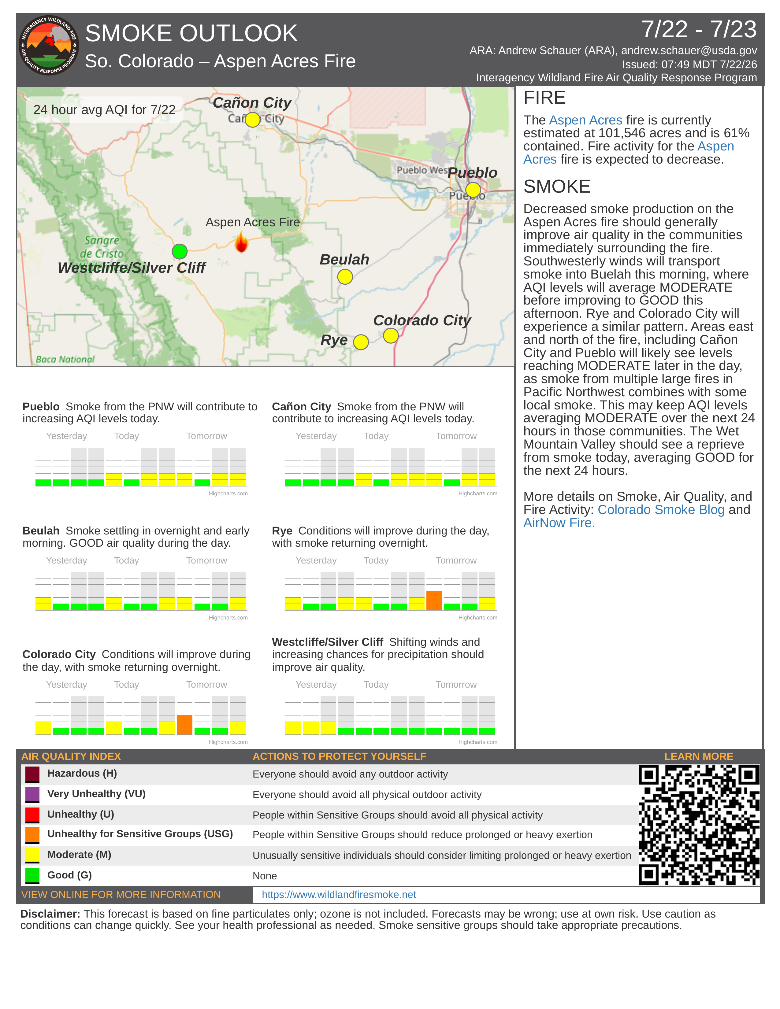
AIR QUALITY
An Air Resource Advisor is assigned to the incident and assessing where communities may be impacted by smoke. To get daily air quality information, visit https://fire.airnow.gov/
OFFICIAL WEBSITES
The public and members of the media should monitor the following official websites:
Follow Pueblo County Sheriff's Office Facebook at www.facebook.com/PuebloSheriff and X: @PuebloCountySO https://x.com/PuebloCountySO.
Follow Custer County Sheriff's Office Facebook at https://www.facebook.com/CCSOAdmin; on Instagram at https://www.instagram.com/custercountycosheriff/ and on X at https://x.com/CusterSOcolo.

Image Gallery